SA Gybe Turkeys (SA, Australia) - 2008-11-08
Sailor 2 Second Peak (Kts)5 x 10 Second Average (Kts)1 Hour (Kts)Alpha Racing 500m (Kts)Nautical Mile (Kts)Distance Travelled (km)
Bubs
28.361 [PB](X)
26.694 [PB](X)
13.275(X)
10.796(X)
17.274(X)
34.72(X)
Average
Bubs (476km):
5888 days ago
6 categories

Well what can i say, the PS's speak for themselves a lot. Awesome days sailing at Goolwa with the bank being exposed. Firt time i've had a go on it and it was awesome. Was about 15 t0 20 knots but a bit square to get real real fast speeds. Still ultra flat though and awesome fun sailing. Very happy with my day anyway and both Dad and Pittsy also had a great sail. A real pitty though that Dad didn't get a go on the GPS (headed in early) because he would have certainly had big PB's as well. Would have also been very nice to get a team post in.

Well i headed out at first with the Starboard S-type 93 and a 5.0 Neilpryde Core. Had a couple runs on that but then it died down and i struggled back then changed to the 5.8 Gaastra Grind which was much better. Good to get a distance PB with the nice longer runs too.

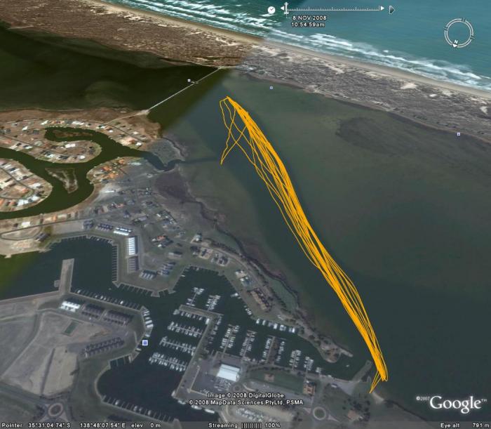
Below is my GPS track for the day: I will also put some photos up on seabreeze that Dad and I took tonight which show the bank a everything. However most are a bit blury unfortunatley because i was cold and couldn't hold my hands still after sailing.

Cheers

Bubs


Comments
Hardie


WA
Australia
5888 days ago

Super Star Bubs well doneCool

Firiebob


QLD
Australia
5888 days ago

Well done Bubs, ya gota be very happy with that mate Cool

Tell the old bugger to cough up for another GPS Wink

Pat O'Connell


VIC
Australia
5888 days ago

Well done on the PBs Bubs

evets


WA
Australia
5888 days ago

Excellent speeds there Bubs, well done. thanks for posting the google earth image, very interesting to see the geography of where you sail. In common with Hardies (in the Peel Inlet in WA) it is close to the ocean but seperated from the swell.I can see you followed a channel. Was there sailable depth water either side as appears to be the case in the image or was there just the channel?


Bubs


SA
Australia
5888 days ago

No the channel on this wind direction is all there is to sail (other than back the other way towards the bridge). The bank i'm sailing close to is completely out the water creating untra flat water. The water levels in the Murray river at the moment are so low that this is what happens. Not good at all, but may as well take advantage of it while it's like it is. only a year and a half/two years back i would sail straight out from the other side of water across the sand. was always shallow but now thats never possible... Have a look at the pictures i'm just uploading onto seabreeze and you might get a better idea, taking a long time though sorry. The pictures were taken from a point in the bottom right of the map, looking down the channel. A few were also taken looking straight out or back toward the bridge.


Bubs

Stribo


WA
Australia
5888 days ago

Very nice work bubs Cool